Sygic GPS Navigation & Maps
- 4.2
- Rating
- 50.00M
- Installs
- Free
- Price
 Analysis by App-foxy
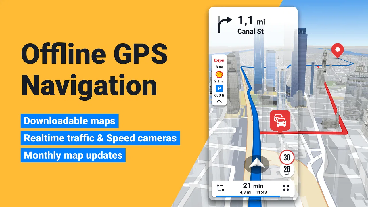
When I use a navigation app, I am not only judging whether it can draw a route. I also want to know how much control I have before a journey begins, what happens when I lose signal, and whether the app feels understandable when I am driving. Sygic GPS Navigation & Maps stands out because it is built around offline maps, 3D map views, and compatibility with Android Auto, while still being available as a free Travel & Local app.
My overall impression is that it is a serious option for drivers who want more than a basic map screen. It has the feel of a dedicated navigation tool rather than a simple place-search app. At the same time, its broader feature set means there are more choices to examine, and some useful capabilities are connected to in-app purchases. I would recommend trying it carefully, especially if you regularly drive through areas with weak mobile coverage or travel across borders.
Why trust matters with a navigation app
Navigation apps are unusually personal. They can be used while I am moving through my neighborhood, commuting to work, visiting a hospital, or crossing an unfamiliar country. That makes the practical experience of control important: I want to understand what I am selecting, when a route is being calculated, and which parts of the service I actually need.
You May Also Like

 AccuWeather: Weather Radar
AccuWeather Review: A Quick, Clear Forecast for Everyday Decisions
For everyday plans, the best forecast is the one you can understand quickly. AccuWeather makes rain timing, radar, and local conditions easy to act on, with a few trade-offs.

 Hill Climb Racing
Why Hill Climb Racing Still Turns Crashes Into One More Run
A tiny car, a bumpy hill and one more upgrade: Hill Climb Racing keeps resurfacing because its simple chaos makes every near-miss feel personal.

 AliExpress - Shopping App
AliExpress Makes Global Shopping Feel Personal, but Shoppers Bear the Risk
AliExpress turns a global marketplace into a pocket-sized discovery engine. Its reach is useful, its shopping loop compelling, and its trade-offs easy to miss.

 Lords Mobile: Kingdom Wars
Lords Mobile Is a Kingdom-Building Routine, Not a Quick Match
A case-by-case verdict on the building, battles, device demands, and social commitments that make Lords Mobile rewarding for some players and exhausting for others.

 PDF Scanner app - TapScanner
TapScanner Makes Paperwork Easier to Capture, Check, and Share
TapScanner makes scanning with a phone feel less like a rescue operation and more like a dependable step in getting work done. Its capture tools are useful, though not flawless.

 Block Blast!
 Shows How Much a Puzzle Game Can Leave Out
A quiet grid game shows why puzzle players increasingly value instant clarity, repeatable skill and low-pressure play—and where the genre still needs to catch up.
More From Our News Desk
View All News


Sygic is developed by Sygic and has been available since November 5, 2010. Its long presence in the navigation category and its broad user base make it a familiar name, but popularity alone is not a reason to install anything. I still look at whether the app suits my habits. A navigation tool can be widely used and still be the wrong fit for someone who wants the simplest possible interface or depends entirely on live traffic information.
The app is free to install and is rated for Everyone, which makes it approachable for ordinary household use. It has an average rating of 4.2 from around 1.9 million ratings, with more than 50 million installs. Those figures suggest that it has reached a substantial range of drivers, but they do not remove the need to test it on the routes that matter to me.
What I like about the trust question here is that it can be approached through visible choices rather than assumptions. I can decide whether I need offline navigation, whether I want to connect the app to a vehicle display, and whether a paid option is worthwhile for my own trips. I would not treat the app as a magic replacement for checking road signs, particularly when construction or local restrictions change faster than any map can be updated.
Offline navigation changes the planning routine
The most meaningful reason to consider this app is the offline map approach. Before a trip, I can prepare the areas I expect to visit instead of assuming that a strong mobile connection will be available everywhere. This is especially useful on rural roads, in underground parking areas, during international travel, or in places where roaming is expensive or unreliable.
There is a small but important discipline involved: offline navigation works best when I prepare before leaving. I would not wait until I am already outside coverage to discover that a required map area has not been downloaded or selected. I also prefer to check the route while connected, because planning is easier when I have time to review the destination and recognize possible alternatives.
Offline capability is not the same as having every live road condition. A stored map can guide me when the network disappears, but it should not make me assume that it knows every temporary closure, traffic queue, or newly changed turn. My practical workflow is to check conditions before departure, save the necessary map area, and then keep an eye on physical signs during the drive.
How I approach the map and route screens
The 3D presentation is useful when I need more visual context than a flat line on a map. In an unfamiliar city, buildings, junction shapes, and the direction of the road can be easier to understand when the display resembles the scene ahead. I find this most helpful near complicated intersections, where a simple arrow may not immediately tell me which lane or road branch to follow.
However, a 3D view can also become visually busy. I would set it up before driving rather than experimenting with map styles in motion. The safest arrangement is the one that lets me recognize the next instruction quickly without staring at the screen. If a flatter view feels clearer to me, that is the better choice; visual realism is not automatically better navigation.
Android Auto compatibility is another practical advantage for drivers with a compatible vehicle setup. Seeing navigation through the car’s display can reduce the need to handle a phone, and it places the route closer to the other driving controls. I would still configure the connection while parked and confirm that the route, voice guidance, and map view behave as expected before relying on it for a long journey.
A realistic everyday journey
Imagine I am driving from a city apartment to a countryside rental for a weekend. The first part of the trip has dependable coverage, but the final roads pass through valleys where the signal is inconsistent. I would search for the destination while connected, prepare the relevant offline map area, review the route, and then place the phone in its normal driving position or use Android Auto if available.
On the way, I might encounter a closed lane or a local diversion. This is where I would treat the app as a helpful guide rather than the final authority. If the displayed route conflicts with a temporary road sign, I follow the sign and reassess the destination. The offline map helps me continue when the connection drops, but it does not eliminate the need for ordinary road awareness.
For the return trip, I would repeat the same check instead of assuming that the outbound route remains ideal. Weather, events, construction, and local access rules can change the sensible route. This preparation habit is one of the best ways to get value from the app without placing too much trust in any navigation service.
Understanding the paid choices
The free entry point is useful for testing the basic experience, but the app also offers in-app purchases ranging from $0.99 to $89.99 per item. That is a wide range, so I would avoid buying anything simply because a screen presents an upgrade during setup. I would first identify the exact problem I am trying to solve: offline coverage, a particular navigation enhancement, or a feature needed for a recurring journey.
My advice is to use the free experience on familiar routes before spending money. Familiar roads make it easier to judge the interface, voice instructions, map readability, and route behavior without the stress of learning a new area. If the app becomes part of my regular travel routine, I can then decide whether a paid option offers enough practical value.
This is also where user agency matters. I want to know what I am purchasing before confirming it, whether it is a one-time need or something connected to continued use, and whether the feature is relevant to my driving style. A high-priced option may make sense for a frequent traveler but be unnecessary for someone who only needs occasional directions around town.
Data-sensitive moments during setup and travel
Navigation naturally involves sensitive moments. Entering a home address, searching for a workplace, saving a hotel, or planning a medical visit can reveal patterns about where I go. I therefore pay attention to the choices shown during setup and while using the app. I do not enter more personal information than I need for the route I am planning.
My preferred habit is to search for a destination by its exact public address when possible, rather than creating a large personal collection of saved places immediately. For a one-off trip, I may only need the destination for that journey. For a regular commute, saving a place can be convenient, but I would periodically review saved destinations and remove ones I no longer use.
I also distinguish between navigation and account convenience. If the app presents account controls, I would read what each option does before enabling it. I would look for settings related to saved places, synchronization, notifications, and personalization, then keep only the choices that genuinely help me. Clear control is more valuable to me than enabling every available option.
Because the app is used while driving, notifications deserve attention too. Unnecessary prompts can distract me at exactly the wrong time. I would configure the app while parked, reduce interruptions where the available settings allow it, and avoid changing preferences during a journey. The safest navigation setup is one that gives me the next instruction without demanding repeated interaction.
Permissions and visible choices
I judge permissions by whether they make sense for the task I am asking the app to perform. Location access is central to turn-by-turn navigation, but I still prefer to review the permission prompt rather than approving everything automatically. If the operating system offers a choice between different levels of access, I select the one that matches when I expect to navigate.
I also check the device’s application settings after installation. This gives me a second opportunity to review permissions and notifications in plain language. If I am only planning a trip occasionally, I may choose a more limited arrangement when practical, then adjust it when I need active guidance. The exact choices available can depend on the phone and operating-system version, so I treat the system controls as part of my review process.
Account controls deserve the same attention. I would use an account only when its benefits are clear to me, such as making a particular workflow easier, and I would avoid assuming that an account is required for every basic navigation task. If I later stop using the service, I would check the app and device settings for sign-out, stored places, and notification controls rather than simply deleting the icon and forgetting about it.
These steps are not unique to one navigation product, but they matter especially here because the app can become part of a daily driving routine. The more often I use a tool, the more important it is that I understand its choices instead of treating setup as a one-time formality.
Where it beats familiar alternatives
Compared with a basic online map app, Sygic’s strongest distinction is the emphasis on offline navigation and its dedicated 3D presentation. A general map service may be excellent for searching businesses, reading place information, or checking a route quickly, while this app feels more focused on the driving journey itself.
That focus can be a benefit when I am preparing for a long trip or traveling somewhere with uncertain coverage. I can think about map availability before departure instead of discovering the problem halfway through the journey. Android Auto support also makes it a more natural candidate for drivers who want navigation integrated into the vehicle display.
The trade-off is that a general map app may feel faster for a simple question such as finding a nearby café or checking opening information. If my main need is local discovery rather than structured driving guidance, I may prefer the broader search habits of the usual map alternatives. I would choose Sygic for route preparation and offline confidence, not automatically for every location-related task.
Live traffic is another area where expectations should remain realistic. Any driver who depends on constantly changing congestion information should compare the app’s current capabilities and settings with the service they already use. Offline strength and real-time awareness solve different problems. One helps when connectivity is limited; the other helps when conditions change minute by minute.
Who should use it and who should skip it
I think the app is a good match for road travelers, commuters who pass through weak-signal areas, people driving internationally, and anyone who prefers to prepare maps before leaving. It is also worth considering if a 3D view helps me understand complex junctions or if Android Auto is an important part of my car setup.
I would be more cautious if I only need occasional directions in a familiar city. In that situation, a simpler map tool may involve less setup and fewer decisions. I would also skip it if I am unwilling to prepare offline maps before a trip, because the headline advantage then becomes much less useful.
Drivers who want a completely hands-off experience should remember that no navigation app removes the need for attention. I still need to obey signs, watch the road, and make sensible decisions when instructions conflict with visible conditions. The app should support my judgment, not replace it.
My practical setup checklist
Before relying on the app for an important trip, I would follow a short routine:
- Install it and test the interface on a familiar route while parked or before setting off.
- Prepare the offline map area for the destination and the roads around it.
- Review the route rather than accepting the first line without looking at it.
- Check location, notification, and account choices in the app and the phone’s settings.
- Connect Android Auto before the journey if I plan to use the vehicle display.
- Keep physical road signs and temporary diversions as the final authority.
This checklist addresses the most common point of failure: not the map itself, but assuming that installation equals preparation. A few minutes before departure can make the offline feature much more useful and can prevent me from trying to adjust settings while driving.
My cautious verdict
Sygic GPS Navigation & Maps is a capable choice when I want navigation designed around prepared routes, offline map access, a 3D view, and Android Auto compatibility. Its free availability makes it easy to evaluate, while the paid options mean I should make upgrades based on a real need rather than impulse. The app has enough depth to reward careful setup, but that same depth may feel unnecessary to someone who wants only quick local directions.
My recommendation is strongest for travelers and drivers who regularly face unreliable connectivity. I would install it, test it on ordinary journeys, prepare one offline trip, and review the visible permission and account choices before making it part of my routine. I would not use its popularity as a substitute for checking whether the interface and route information work for me.
In the end, I see it as a useful navigation companion rather than an unquestionable authority. The best reason to choose it is control over trip preparation when the network cannot be trusted. If that is the problem I need to solve, it deserves a serious trial. If I mainly search for nearby places or want the least complicated map experience, a more general alternative may suit me better.
FAQs for Sygic GPS Navigation & Maps
01What features does Sygic GPS Navigation & Maps offer?
Sygic GPS Navigation & Maps provides a comprehensive suite of features, including offline maps, voice-guided navigation, real-time traffic updates, and speed limit alerts. It also offers lane guidance, junction views, and pedestrian navigation. Users can benefit from features like parking suggestions, fuel prices, and dashcam functionality, making it a versatile navigation tool.
02Is Sygic GPS Navigation & Maps free to use?
Sygic offers both free and premium versions of its app. The free version includes basic navigation and access to offline maps. However, to unlock advanced features such as real-time traffic updates, Head-Up Display, and dashcam, users need to purchase a premium subscription. This flexibility allows users to choose the level of service that best suits their needs.
03How does Sygic handle offline navigation?
Sygic excels in offline navigation by allowing users to download maps for entire countries or regions directly to their device. This means you can navigate without an internet connection, which is especially useful in areas with poor connectivity. The app provides comprehensive map data and detailed routing, ensuring accurate and reliable navigation at all times.
04Can Sygic GPS Navigation & Maps be integrated with other devices?
Yes, Sygic supports integration with various devices and platforms. It can be used with Apple CarPlay and Android Auto, allowing users to access maps and navigation on their car's display. Additionally, the app can sync with smartwatches for on-the-go navigation assistance, making it a versatile tool for tech-savvy travelers.
05What are the system requirements for Sygic GPS Navigation & Maps?
Sygic GPS Navigation & Maps is compatible with both Android and iOS devices. It requires Android 5.0 or higher and iOS 13.0 or later. The app is optimized for both smartphones and tablets, ensuring a smooth user experience. Adequate storage space is necessary to download offline maps, so users should ensure their device meets these requirements.
Pros
- Offline maps for global navigation.
- Real-time traffic updates enhance routes.
- User-friendly interface with intuitive design.
- Customizable voice navigation options.
- Regular updates with new features.
Cons
- Premium features require a subscription.
- Initial map downloads can be large.
- Occasional inaccuracies in route suggestions.
- Battery consumption can be high.
- Limited support for pedestrian routes.

Sygic GPS Navigation & Maps
Gallery